Wednesday, November 14, 2012

The Quest For The Last Frontier 1

I had a hard time time thinking of what title I would write for this blog. Palawan is a very nice place so I must give justice to it. I have heard that Palawan is now called "The Last Frontier" and I didn't know exactly how to interpret it. I searched for some articles to make sure of it, and it's confirmed! And do you know why? Because it is the last unsettled area in the Philippines, a home to many tribal groups such as Tau Batu, The Batak and the Tagbanuas. It is composed of 1,700 islands which I believed some of them hasn't been explored. The island is largely formed by a mountainous ridge covered with rich vegetation that harbors endemic animal species despite of deforestration and occasional fires.


At Sabang Port in Puerto Princesa
I thought that I only had few relatives in Palawan like what had in Ilocos. I don't have any idea that some of them had settled down and raised their own families. It was my first trip in Palawan and I was eager to see my relatives after so many years. Four days wouldn't be enough to explore Palawan, and we chose to take a 2-day packaged tour and the remaining two days would be for us to freely move around the place without time pressure. I guess you know how it is to be in a tour package, you can't really sneak out of it.


Our first day was raining and the first destination was the Underground River. The sea was rough during the ferry ride due to the heavy rains and the surge of giant waves kept on colliding with the boat. The boatman had a hard time docking the boat because of the strong current which keeps the boat away from the shore, we have to disembark quickly or we'll get soaked! Walking along the wooden trail leading to the mouth of the cave was pleasant enough to get over with the stressful ride. The rich forest is a habitat for a diversity of flora and fauna on earth. Monitor lizards passed by, monkeys loiters around, butterflies in different colors, crickets, bees, flowers and I think there are more in places unexplored! 


It is with great pride and honor to see one of the Seven Wonders of Nature which boasts of 500,000 to 1,000,000 monthly visitors from around the world. One would be proud to be a Filipino and to belong to a country so blessed with natural resources and recognized globally. At the end of the trail is the mouth of the cave and the line of people waiting for their turns with their eyes all focused on the cave.

Mouth of the cave.

As the boatman/tour guide paddled slowly on the calm water of the river, the sight of the dark cave was orphic preternatural and made me quiver. Do you have an idea how dark it was in the cave? Just close your eyes for a second and that is that! You won't see anything, the cave smelled bat urine and merges with the smell of the river and the damp cold air which confirms that everything in there is pure organic.


Mushroom formation.


Corn formation.
Guess what formation?


Stalactites formed into an image of the Holy Family, animated characters, dinosaur and many more were apparently the residents of the cave for thousands of years, apart from the bats, birds and cold blooded creatures. There is a dome in the middle part of the cave, similar to St. Paul Cathedral in London. According to the tour guide, a British explorer discovered and named it St. Paul Underground River Park which it was formerly known.  But the local tribes has another story, they say that the "Tagbanuas" were the first to know about the cave and was inhabited by fairies, sounds magical! Yes, the natives could be right, the fairies could be the rightful owners and the sculptors of the cave and I am talking about the mythical aspect. While scientifically speaking, the mineral water were responsible for its formations, but how were they molded into forms which appears like people and things familiar to us?


Underground highway.

Well, all I can say is that the 45 minute tour was rewarding and quite entertaining due to the punchlines delivered by the boatman. "Ang kuweba daw ay nagsasara at 12 noon"
(The cave will be closed at 12 noon). I thought the river would rise and fill the cave, but it's not!
And why is that? Punchline: "kasi daw lunchbreak nila"! (it's their lunchbreak!).
Funny! Haha.
er can tell. Maybe, 
Into the bat cave!


This is just our first tour in Palawan, I will be writing about my next adventure on my next blog and I hope you'll find time reading it. Thank you for reading!

Sunday, November 4, 2012

Jewels Of Ilocos Norte Part II


It's getting dark and we have to find a place to stay in Pagudpud (Pa-good-pood), we haven't made reservations on any resorts, homestays or hotels, so we have to hurry before I get hungry!
The town of Pagudpud was once a barangay of Bangui town. It only became an independent municipality in 1959 when a group of political leaders petitioned to separate Pagudpud from Bangui was granted. My anxiousness was comforted as I saw the white arch with that bold green letters 
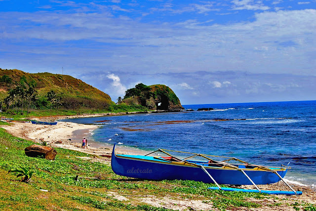
"PAGUDPUD" on it and I grinned with excitement! The road going to Pagudpud has a firm surface, you will pass by greenwoods  and vegetations on most front yards of the locals, which shows how diligent and resourceful Ilocanos are.  Rice farming and fishing are their main source of income. The place is  a favorite tourist destination during summer  for its vast and magnificent gold sand beaches. There are a number of beach resorts on the coast, Saud Beach Resort and Pannzian Beach Resort to name a few are the most popular. The municipality also encourages homestay for visitors who would want to learn the Ilocano lifestyle.


Travelling for three days was exhausting, and because we don't have a place to stay, finding for it makes it more tiring. We did some house hopping in the town proper, there were many  houses to choose from but they didn't really suits our liking. Until we came across a pretty peach house while on our way to leave the town and read the small signage hanging on its garage saying "Josie's Homestay"! We stopped and looked for the owner and met "Manang Josie". She let us in her house and gave us a  fair rent for the two rooms we'll occupy. Manang Josie's house is very spacious and can accommodate a number of tourists. The round dining table is big enough for a family of twelve. The kitchen area is complete with utensils and the landscaped garden is  surrounded with colorful hibiscus. Picnic huts are available in case you want to dine  al fresco. Tents are also allowed in the commodious garden, just ask the owner and she'll be willing to lend and set it up for you.


Time is running and we still have many places to go so we have to step on the gas! Not far from Manang Josie's house is the beautiful place of Balaoi, where more treasures can be found! The enchanting Kaibigan Falls which is just a 30-minute trek from the main road is like a walk in the park. Mang Joe our tour guide told stories about the place, tales about how it got its name, the culture of the people and how they protect the environment. It is pretty obvious how patient they are in maintaining its grace.

Is there a sight more heartwarming being greeted by a pair of ducks dabbling on the stream?


And walk along the fertile trails of rice farms, with the clouds and the forests touching each other? The smell of fresh air and the vivid foliage which we passed by gives an impression that a natural wonder awaits!


The flow of water in the brook plays a melody while it surge from one rock to another and while being shaded by abundant greenery. I didn't notice the time spent on walking, when I suddenly heard a loud gush of water!


And that's it! The white flow of water looks so immaculate from where I was standing, I hurriedly went nearer to see how pure it is, I took a dip and the water was so cold! Kabigan derived from the word kaibigan (friend) has its own legend to tell. The falls is approximately 87 feet with a concave basin underneath to hold the water, and for the tourists to enjoy. It is sad that we have to leave this natural garden at once, I took several pictures of it for me to keep and cherish.


If your imagination is very creative, at a distance... you'll think that the Bantay Abot Cave is a great whale docked on the shore, isn't it? No? Well for me, it is! Sometimes it amuses me to visualize the physical world into something entertaining, my thought can give them more life and character. The Bantay Abot cave is actually a big rock with a hole in the middle, it was formed due to the powerful waves which smashes the hill, and it is situated in Balaoi, you'll pass by it on your way to Maira-Ira Point which is just a few meters away from Bantay Abot Cave.


After spending sometime in taking pictures in Bantay Abot Cave, we went to Maira-Ira Point popularly known as Blue Lagoon. I was very curious at first why it is called Blue Lagoon, the first thing which came to my mind was Brooke Shields who starred in the famous film with the same name, the only difference is that this place is prettier than her.


There are a number of beach resorts in the area which usually offers homestay, so tourists can enjoy their vacation. There are also cavanas along the beach which can be hired for a fair amount if you're only planning to stay the whole day. And since we'd like to relish the beauty of the place we chose to pitch a tent, play frisbee on the shore, frolic in the sea, watch the splashes of waves, whistle while the clouds pass by, and quench our thirst with ice cold beer.


How can I resist the clear water of Blue Lagoon with its fine white sands which didn't even hurt  my feet? The inviting waves which comes and go as if calling me to embrace the cold water?


Hitting the road again, after passing time in Blue Lagoon, we found ourselves in a concrete winding long bridge along the coast of Pasaleng Bay, the Patapat Viaduct. This bridge connects the Maharlika Highway from Laoag, Ilocos Norte to the Cagayan Valley Region.
This viaduct was constructed to solve the problem of landslides in the area which have caused so many vehicular accidents in the past. You know, you can do a lot of things in a road while it is not busy, you can do planking, you can take jump shot pictures as much as you can, sit in the middle of the road, scream, or just stand and enjoy the spectacular view of the seascape. Just make sure no vehicles are coming.


You wanna go here? Hurry don't be too late!

The Patapat viaduct is about 16+ kilometers from Pagudpud, Ilocos Norte.  From Pagudpud, simply head northeast towards Cagayan. The landscape changes if you continue along the northern road leading to Claveria, but we were not able to go on due to time constraints, we have to go back to Ilocos and go home. But my journey doesn't end here, there will be plenty of time soon.

The province of Ilocos Norte is rich in history as well as nature sites of great beauty, and I admire the Ilocanos for their dedication in preserving its treasures that until now they are still in its priceless glory.

Thank you for reading.

Tuesday, October 23, 2012

The Jewels Of Ilocos Norte...Agbiag!!

Our journey went farther to the north of Ilocos Region, where more of its treasures can be found. I was only about 5 years old when I first went to Ilocos Province. It  is my father's hometown, and he spent most of his childhood days in Batac,  according to some of my relatives, he and his siblings were President Marcos' (former Philippine President) playmates and I thought about how Batac looks like during those days.  I thought about how they ran in the streets, climbed trees and spent their time after school. I was very young when I went there, very young that I should have forgotten by now all the things that I've seen and experienced during my stay.  The"duhat" trees which lined along the streets on our way to Curimao beach, the raft on the beach, the calesa, the "dinuguan" we had for dinner in the garden, the artesian well, the "tuko" (gecko) which keeps on croaking in the middle of the night and the playmates I've met,  all these are sweet memories that still lingers in my mind.

Hmmm empanada and roasted peanuts with lotsa garlic!


And after several years,  I've finally returned to Ilocos and it looks different now. Buildings and commercial establishments are everywhere, some streets are wider and paved and some are narrow due to the volume of trucks, buses, jeepneys and tricycles running in the main streets. I rarely saw "calesas". But there is one thing that still hasn't changed in Batac, it's their flashy orange crispy fried "empanada" in the plaza which always goes with vinegar and garlic that makes everyone crave for it. Those grilled dried squids on sticks displayed on glass shelves, smells a bit fishy but still taste good is a sure winner!

Yummy!

So let's continue our journey to the quaint town of Paoay (Pawai), which we all  know is very popular for its monumental church. I only see this church in pictures and I was awed while standing right in front of it! The Church of Saint Agustine and its adjoining coral stone bell tower was constructed by the Augustinians in 1694. It is one of the most famous and magnificent building in the region which is listed in the World Heritage Site of UNESCO. The two sides of the facade are extended by curved buttresses giving it a graceful air.


Grand architecture!


Its astounding facade displays an immense decor with its massive flying buttresses which gives protection from strong earthquakes. The artistic creation emerges from a beautiful open space, unlike any many other churches located within the urban settings. How do you like that?


Our journey in Paoay wouldn't be complete if we miss the Malacanang of the North and Paoay Lake.  We passed by this beautiful two-story vacation house of the former Philippine President Marcos which is now turned to a museum displaying the Marcos memorabilia. It is also a popular venue for  wedding receptions and other special events. The museum is open from 9 am until 5 pm with an entrance fee of 20 pesos. 


It has a spacious terrace and a beautiful garden at the back  with a splendid view of the Paoay Lake. Legend tells that Paoay Lake was once a beautiful dry land. The site of a prosperous barangay called San Juan de Sahagun (Saint John of Sahagun). The materialism of its people has angered God so He sent an earthquake that sank the town. The lake remains to be mystical according to the locals, jewels and gold ornaments on the mouth of fresh caught fish are said to be found by fishermen  as proof that the villagers then lived a lavish lifestyle.


I thought I was in Sahara desert when we drove along the wide scope of dry landscape. I walked and ran onto hills of sands and it hurts my feet due to the scorching heat of the sun. The 85 kilometer Paoay sand dunes seemed to be the favorite setting of most Philippine films like "Panday", "Himala" and some other films. What intrigues me most is that how did dunes existed in a tropical country? Could it be under sea water millions of years ago? Or could it be the effect of strong earthquakes which made the ocean move back leaving all these sands? Oh well...what I know is that the place is starting to attract tourists and is now a haven for thrill seekers who would want to try some sand adventures!

walang himala!

Heading north again, we passed by an old lighthouse in Burgos, Ilocos Norte. Burgos was named after the martyred priest Jose Burgos who was executed in Manila, it is 50 kilometers north of Laoag. The red brick lighthouse, Cape Bojeador, was constructed in 1892 by the Spaniards. I must admit that I got scared with the ghostly atmosphere as I walked on its creaking wooden aisles along old wooden thick doors, with a height three times as mine. In spite of the ravages and natural elements which damaged it severely, the building still shows  the elegance it had during the old days. Today the Burgos Lighthouse still stands on a hill and continue to attract tourists and serves as beacon to all passing vessels along the Philippine sea.

Creepy.

Ilocos Norte is really trying to impress me more, I have been to a historical church, a legendary lake, sand dunes, an old lighthouse and this time... windmills? I screamed as the car passed by the main road when I saw the rows of gigantic fans from afar which still looks huge even at a distance! Honestly, the windmills excites me the most as we passed by the coastal town of Bangui. It is odd to see windmills in a small and simple coastal town. The locals must have something to be proud of and I'm telling you it gave me a different feeling as I went nearer and touched its base, see them twirl and makes a loud squeaking sound!


The windmills, officially referred to as the NorthWind Bangui Bay Project, were a project by the NorthWind Development Corporation as a practice renewable energy sources and to help reduce the greenhouse gases that cause global warming. The project is the first “Wind Farm” in the Philippines consisting of wind turbines on-shore facing the South China Sea and considered to be the biggest in Southeast Asia. The project sells electricity to the Ilocos Norte Electric Cooperative (INEC) and provides 40% of the power requirements of Ilocos Norte via Transco Laoag.

How to get here?
From Laoag, take the Laoag-Cagayan route towards Burgos. After reaching Burgos, watch out for the directional marker on the left side of the road that leads to the Bangui Bay. Follow the dirt road leading to the bay. Some wind mills will already be visible from this point then make a right turn to the bay. Travel time from Laoag will approximately be an hour and a half.

"One's destination is never a place, but a new way of seeing things."-Henry Miller

Thank you for reading!

NOTE: Some informations in this blog were taken from the book. "Places With A Heart Philippines".


Friday, October 19, 2012

The Charm Of Sta. Maria, Ilocos Sur

I will not forgive myself if I fail to mention my story in Sta. Maria, Ilocos Sur. I should have included this in my previous blog about Vigan but I chose to compose a special one for it. Sta. Maria is in the western coast of Luzon in the Ilocos Region. A town ahead of Vigan City and omitted at times by tourists which is very regretful because the town keeps one of the four Baroque Churches in the Philippines,  listed on UNESCO's World Heritage Site!


It will take 5 hours to get there by land from Manila and that is... if you're not going to make several stops along the way...like we did. But we have to make a quick stop at La Union to go to the restroom, eat breakfast,  and watch the sunrise for dessert,  then hit the road again, how quick was that?

Happy fiesta!
My first visit to Ilocos Sur was 5 years ago, when we had a tour in Vigan City. I have no idea why we chose to rest and stay for the night in Sta. Maria on my second visit, while it is only an hour away from Vigan. I had an impression that there is something in Sta. Maria that we need to find out! The next morning, while we were on our way to Vigan City, the resort staff told us to pass by their town's beautiful church on a hill. Since it's our practice to visit churches on places we visit for the first time, we followed the way going to the church. And guess what? A grand architecture of heavy stones, bricks and mortars stands firm on a hill overlooking the central town plaza and the vast plains and hills of Ilocos. The Nuestra Senora dela Asuncion Church was built in 1765 during the Spanish regime. Unlike its sister churches in Ilocos Region, the Santa Maria church was less in proportion and expresses tightness in space but has an elaborated architectural design.  


The thick buttresses of the church attached to its walls gave more force to the structure against strong earthquakes which often hits the town.


A detached pagoda-like bell tower was later constructed in 1810,a distance away from the church to protect the main church from possible earthquake damage. The octagonal bell tower was furnished in 1811 and was remodeled in 1863, its foundation must have gradually settled down making the structure appears slightly leaned or tilted.


And according to legend, Santa Maria Church was not built on its present site and that the statue of the Virgin Mary was enshrined in a distant place. It often happens that the statue of the Virgin Mary disappears from her place of enthronement only to be found perched on a guava tree that grew on a hill and where the present church is located. This story is believed by the locals which had led them to erect the church on its present site.


Partly blocking the frontal view of the facade of Santa Maria Church is the convent. It is accessible from the Church by a structural bridge built over which might have been a deep channel or ditch. In the early days of the colonization, the convent was the seat of the ecclesiastical administration besides serving as a “ home or retreat house of the silvery haired or aged ministers of God upon their retirement.


I roamed around the area and found a long trail not far from the church with tall old trees and weeds that almost covered the path, the cave-like opening at the end of it made me more curious to know what is there really!


Pink little flowers dangles on trees, parts of the concrete pathway are damaged, old trees with slender branches droops and at the end of the path where an old dilapidated arch covered with weeds made us stop and wonder what this structure is for?


We found out that it was an old cemetery with an octagonal brick fence which I thought was destructed by a major earthquake many years ago. And there I saw a facade of an ancient structure with an image of a human face made from bricks on the upper part of the main entrance or was it only my imagination? It looks so creepy from where I was standing as I look at the dark mouth of the building.


However, we still insisted to proceed and know what was it! And it looks like this structure is a  remnant of  an old burial chapel during the Spanish era, and maybe constructed on the same time the church was built. It could have been damaged by a strong earthquake or destructed during World War II, there were several tombs of Spanish priests and perhaps prominent residents in town. We couldn't find someone to talk to and ask about the history of the place but by just looking at it...it already tells the story.


It was already late in the afternoon when we finished going around, the view of the glorious sunset on top of the hill filled the place with its golden rays. I never thought that the humble town of Sta. Maria in Ilocos Sur has something to be proud of, an edifice which will be admired and uplift the spiritual being of those who will come and visit it. 


Thank you for reading.


Tuesday, October 16, 2012

Wish Vigan Will Not Be Gone


I always imagine Vigan as a place where I can travel back in time, walking in the middle of moonlit cobbled pavements. Wearing a pink "terno"(a type of Philippine traditional dress) and holding an "abanico"(a handheld fan) on a cozy and starry night while sitting on an old but comfortable bench. The sound of clip-clops of horse drawn carriages going around the plaza echoes on a peaceful night and the quaint bell tower stood silently as if watching all the people roaming around the place. Sighs.


Old but elegant.


Going to Vigan City is just 8 hours away from Manila by land. I know that 8 hours of driving is not just, but I swear you will not get bored with the panoramic view of landscapes, seascapes and places with old structures that you will pass by. The Quirino Bridge is one of the most beautiful bridge in the country and famous for its excellent engineering. The bridge was named after the late President Elpidio Quirino and connects the town of Santa and Bantay, Ilocos Sur and serves as the gateway to Vigan City and all the other historical places in the Ilocos Region.


The town ahead of Vigan is Bantay, it is famous for its bell tower which stands on a hill, the structure was built by the Augustinian Missionaries in 1591. The bell tower is situated in the highest spot in town as watch tower during the Spanish regime which corresponds with the name of the town "Bantay" meaning "guard" in English.


People will probably feel nostalgic the same way like I did upon reaching Vigan City. Vigan by the way is approximately 400 kilometers from Manila, and is located in Ilocos Sur, Philippines. It is the only town in the Philippines with so many preserved historic sites and in this manner Vigan was listed in UNESCO's World Heritage Site. Legend tells that Vigan was saved from destruction by the Japanese forces due to a romantic link between a Japanese officer and a charming lady from the region, and with this...I wish to express my gratitude to that beautiful lady for the heritage that has been preserved and that we as Filipinos have been very proud of. 


Old ancestral houses built under the Spanish era still stands in every streets of Vigan. They were made from bricks, woods and concrete and most of them were owned by the most prominent residents in the city, who still maintains and preserves their legacySome of the houses were only restored back to its original condition, due to fire which broke out during World War II that burned several houses. 


My kind of vacation house.


"Calesas" or horse drawn carriages are still being used as a means of transport in Vigan. It was introduced by the Spaniards to the Philippines in the 18th century which only the nobles and high ranked officials could only afford. The calesa driver called as "cochero" directs the horse to turn right or left. Calesas are usually seen in the streets, which are elaborately adorned with colorful curtains and flowers, giving tourists a joy ride around the city for a small fee. 


The city proper.

Souvenirs shops can be found along the streets, plazas and public market. But the shops on the old alleys were the most frequented by the tourists because of its accessibility and cozy atmosphere. They sell tees with different prints, native hats, bags and other locally made products. Vigan is also famous for its burnay industry. The "burnay" are earthenware jars crafted by a potter’s hands with the aid of a potter’s wheel. It uses fine sand (anay) as a tempering material and fired at a high temperature in a huge brick-and-clay ground kiln that makes it harder and more durable than other terracotta. The local bagoong (salted anchovy), sugarcane vinegar and basi wine would not taste as good if not fermented in stoneware burnay jar for your information.


I have been to Vigan twice and do you know why I keep on returning? It's their specialty dish, Vigan ukoy and empanada! You can find these delicious snacks everywhere in Vigan.  The empanada is similar to taco that is fried to crisp. Rice flour is used for the making the crust or shell and the filling is made up of grated green papaya, mung bean sprouts, egg and the delicious Vigan longganisa (native sausage).  Your craving for empanada and ukoy wouldn't be complete without sukang  Iloko (local special vinegar) with onions, garlic and chili. Yum!


Delicious! I swear!


Time for ukoy...yum again!
On the other hand "ukoy" is another appetizing treat after going around Vigan, and it goes well with empanada. Vigan ukoy is crispy shrimp fritter made up of small shrimps and glutinous rice batter and served in Ilocos cane vinegar with garlic, onion and hot chili. As I am writing this blog my stomach began to grumble, it craves for empanada and ukoy and I must go the kitchen and get something to eat. Well that's all for our Vigan tour, I hope you enjoyed reading and I thank you for your time in following my blogs.

NOTE: Some parts of the blog were taken from the book "Places With A Heart Philippines". And the Vigan City Official Website.